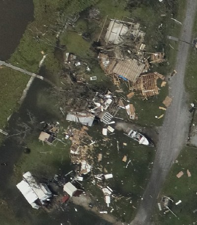
SCOTTS VALLEY, Calif., Sept. 2, 2021 /PRNewswire/ — As Hurricane Ida first made landfall, the storm’s core packed a punch, flattening houses that withstood Katrina. WeatherFlow’s Hurricane Network measured Gusts of up to 172 mph showing that Ida was an extremely dangerous hurricane as it headed towards Baton Rouge. The forecast for New Orleans suggested it would be spared hurricane conditions.
As the storm tracked across the Bayou, a process known as an eyewall replacement cycle, where a hurricane spreads its concentrated eyewall energy over a broader area, was taking place in the depths of the storm; it became apparent that New Orleans was increasingly under threat.
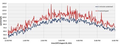
"We noticed something odd happening," says Jay Titlow, WeatherFlow Network’s Chief Meteorologist from the company’s storm operations center. "As the storm came off the Bayou for its second landfall near Houma, LA, the eyewall was no longer packing its previous winds, rather we were observing hurricane force winds in excess of 100 mph in a second, larger eyewall at our weather stations in Dulac and Galliano that flanked the storm. We were also seeing some very destructive gusts in excess of 130 mph."
Eyewall replacement cycles are a phenomenon reserved for hurricane intensification processes over warm ocean waters, and are extremely rare occurrences once a storm has made landfall. WeatherFlow Networks’ array of hurricane-hardened weather stations, in partnership with the Florida Coastal Monitoring Program’s deployable towers, were in the prime locations to capture this event.
Jay continues, "The broadening of the storm brought widespread hurricane conditions into New Orleans, with our Bayou Bienvenue station reporting 86 mph winds gusting to near 100 mph on the east side of the city. The storm winds covered a wide area, with more than 150 home based Tempest weather stations over a 350 mile wide area measuring winds of 40 mph or more."
Hurricane Ida has now been identified as the fifth-largest hurricane to ever make landfall in the U.S. and contributes to the increasing body of evidence that we are seeing a pattern of bigger, more powerful storms driven by climate change.
WeatherFlow Networks’ HurrNet includes 100 specialized weather stations, placed near coastal urban concentrations. While state and federal organizations provide weather monitoring at some key locations, recent years have seen a growing demand for more and better weather data. The HurrNet significantly enhances existing data and fills data voids with the only stations in the world guaranteed to survive and record hurricane force winds.
The ability to closely monitor extreme weather events is essential to reducing the risks associated. You can access more information about the HurrNet here: http://weatherflownetworks.com/hurrnet-the-weatherflow-hurricane-network/
About WFN Holdings, Inc. (WeatherFlow Networks)
WeatherFlow Networks has been installing rugged and reliable weather stations for over 20 years. The weather technology company owns and operates the largest industrial grade private mesoscale observing network (mesonet) in the world. With over 450 stations reporting as frequently as every minute, this network monitors and archives real-time wind and weather conditions along the Atlantic, Pacific, Gulf, and Great Lakes of the United States and Canada.
WeatherFlow-Tempest Inc is a WFn affiliate that helps individuals and businesses mitigate and control the impact of weather.
Megan Alba
318068@email4pr.com
405-973-8077
SOURCE WeatherFlow


